FireShield Intelligence
A fire map tells you where the fire is. FireShield decides what to do about it.
Every fire app can put a dot on a map. FireShield reconciles every source into one picture, computes a burn probability for each coordinate around your house, works out which side the fire is coming from — and turns that into water on the right side of the house, automatically.
Beyond the fire map
Where a fire map stops, FireShield keeps going
A fire map
FireShield Intelligence
MapShows a fire three miles away.
FireShieldWorks out how likely it is to reach your property, how soon, and from which side.
MapShows four agencies’ reports of the same fire, and leaves you to reconcile them.
FireShieldRecognizes them as one incident, so one fire is never counted as four.
MapColors your whole area the same.
FireShieldGives every coordinate around the house its own burn probability, recomputed continuously.
MapLeaves the decision to you, wherever you are.
FireShieldStarts the system itself when the risk crosses your line — and only the zones facing the fire.
From many feeds to one answer
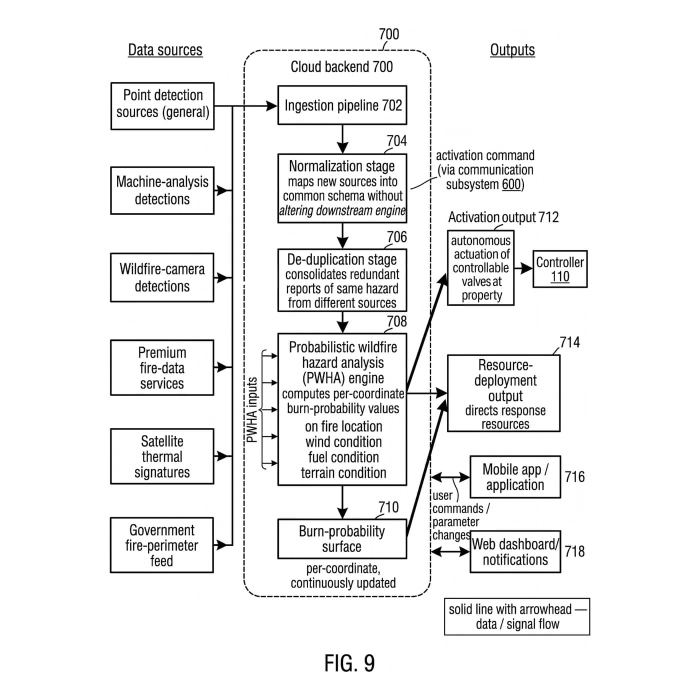
Five steps between a satellite and a valve at your house
01
Take every source
Satellite thermal detections, wildfire cameras, government perimeters, premium fire-data services and on-the-ground detections. A boundary around a fire and a single hot pixel both matter; neither is enough alone.
02
Put it in one language
Every source has its own schema, units and idea of what a fire is. Normalization maps each into one common form — and a new source can be added without touching anything downstream.
03
Recognize the same fire twice
Redundant reports of one hazard from different sources are consolidated into a single incident, so the decision is made on the fire, not on the noise.
04
Compute the hazard
A probabilistic hazard engine weighs fire location, wind, fuel and terrain, extended with burn history, drought, forecast, access roads, concurrent fires, suppression resources and nearby water.
05
Act, and direct
The burn-probability surface drives two outputs: activation of the valves at your property, and direction for response resources across the wider area.
Directional defense
It knows which side of the house the fire is coming from
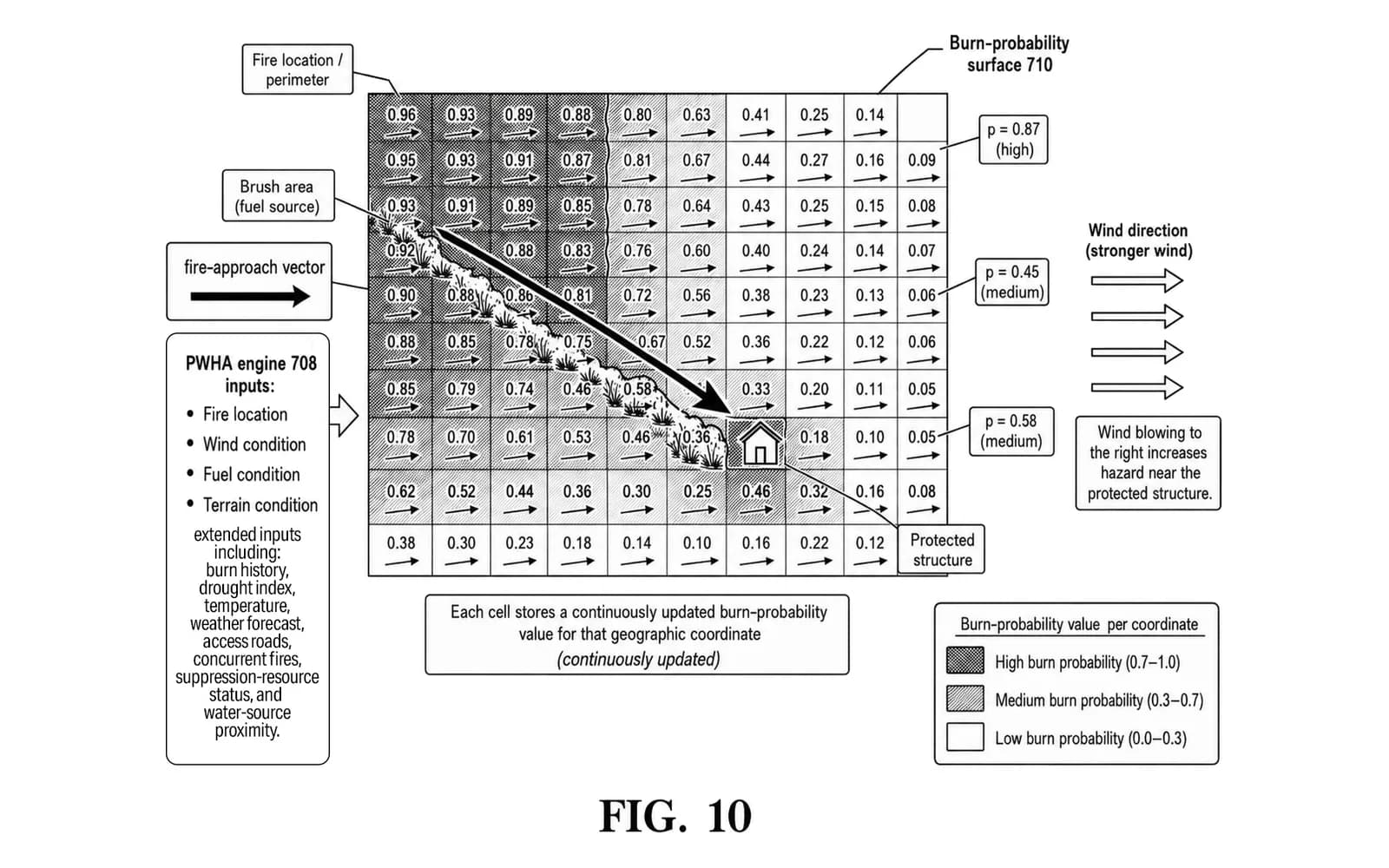
The surface does not just say how close the fire is. The spread of probability across the cells, the fire’s approach and the wind together show the direction it will arrive from.
So when the system starts, it does not spray everywhere at once. It selects the zones facing the fire and puts the water there first — the difference between soaking the side that is about to be hit and running a limited supply dry on the side that is not.
Beyond one house
The same picture can direct a whole response
The surface that opens valves at one property is built for a second job: showing where response resources will matter most across a neighborhood, a portfolio or a region. For communities and agencies it is a shared, continuously updated view of where the hazard is heading; for insurers it is verified, property-level evidence of risk and mitigation.
Autonomous, not out of your hands
It acts on its own. You still have the last word.
A delay you set
When the risk crosses your line, a countdown starts and your phone is told. The length is yours.
Cancel any time
Stop it from the app during the countdown or while it runs.
Start it yourself
One tap in the app, the button on the wall, or a local trigger.
No cloud required
Local and remote triggers work with every network down, and a power cut does not lose its place.
No model can promise what a particular fire will do. What this one gives you is an answer computed from every source at once, continuously — and a system that acts on it while you are still getting out of the way.